Iran is one of the most seismically active countries on Earth. The most recent major earthquake, which occurred in the eastern city of Bam in December 2003, killed 31,000 people. A June 1990 earthquake in Rudbar killed between 40,000 and 50,000. Tehran experienced its last major earthquake in 1830.
Professor James Jackson, head of the Department of Earth Sciences at Cambridge University, first travelled to Iran in 1976, but did not return until 1998. He now visits Iran regularly to study the geology of earthquakes, and to work with the Geological Survey of Iran, a governmental body responsible for identifying and evaluating earthquake hazards. In February, he attended the 32nd National and the 1st International Geosciences Congress in Tabriz. He spoke to IranWire about the risks Iran faces, and the progress its scientists have made.
Have you witnessed the immediate aftermath of an earthquake in Iran?
Yes. I was there two or three days after the Bam earthquake in 2003. I’ve worked for a long time with the Geological Survey in Iran, and we have trained several of their people. The people in Iran know what to do after these earthquakes, but there was a sense of trauma. The earthquake was so horrible that it was helpful for them to have someone from outside to help them make decisions.
One of the tasks after an earthquake is to find out what happened geologically. Of course, there’s a huge humanitarian imperative after the earthquake, but at the same time you have an opportunity, if you go there straight away, to learn from it. What happens geologically in an earthquake is that a fault moves. It doesn’t move very much — maybe a meter or a meter and a half in the case of Bam — and yet repeated earthquakes make the landscape. You learn to recognize the features in the landscape that tell you which places are dangerous and where earthquakes are going to happen. And then you can prepare for them. That approach is pretty sophisticated, and it’s widely practiced in places like New Zealand, Japan, California, and Chile. It’s really in its infancy in most of Asia.
Broadly speaking, what is the main threat Iran faces from earthquakes?
The big hazard is buildings, of course. It’s not earthquakes that kill people; it’s buildings that kill people. In Iran, the population has grown very rapidly since the Second World War, and a lot of the population in cities lives in buildings of poor quality. Iran is not unusual in that respect; it is true throughout the Middle East and Asia.
Many cities are in dangerous locations because the locations themselves are determined by geology. A lot of the cities are on the edges of mountains. The mountains provide the water, but the reason the mountains are there is because of the geology: there are faults that are pushing up the mountains, and the faults cause earthquakes.
How does a large earthquake influence a region’s politics?
It presents an opportunity. After the Bam earthquake, suddenly people in Tehran became extremely conscious of the risks they were living under, and the public had an appetite for hearing about it and talking about it, and that lasted for a year or two. For a short period, the whole business rises up the political priority, and there’s an opportunity at that point to do something, which is very often missed.
What risks does Tehran face?
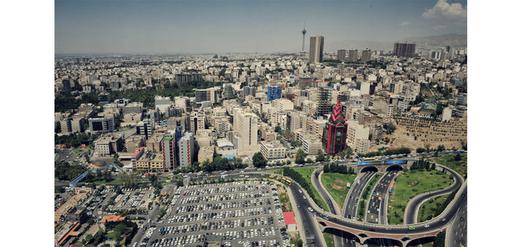
Tehran is in a geological location that is well understood. It is close to faults that are known to move in earthquakes, and Tehran has suffered four large earthquakes that we know about in the last 1,000 years. There will be another large earthquake in Tehran, and Tehran has grown enormously. Tehran is vulnerable because of the quality of its buildings. That is well understood by everybody.
What would be the consequences of a major earthquake in Tehran?
It would be a catastrophe. A lot of it depends on which fault moves, and how big the earthquake is, and whether it happens during the day or at night. What you have to understand is that the last major earthquake was in 1830, and these things don’t repeat that often. There are often several hundred years between them, and so in general, you have some time.
If you make a decision to do something, and you have a few decades of good luck, at the end of that, you’ll be in a much better position. What you’ve got to do is start somewhere. You can’t suddenly replace 10 million dwellings overnight. What you’ve got to start by doing is to make sure that any new buildings, and any modifications to buildings, follow very strict building codes.
It’s clear from big earthquakes in other countries that engineers and architects can design buildings that stay up in even the biggest earthquakes. The problem is corruption and a lack of education. The reason buildings collapse is because of poor construction, and builders trying to save money by cutting corners. That is fatal, always. What is required is that the public is sufficiently educated so they won’t tolerate that.
In Chile, the public will sue architects and engineers and builders if there is any damage to their buildings in earthquakes. The 2010 earthquake in Chile was about the fifth largest worldwide in the last hundred years. It was much, much bigger than Bam, yet it killed very few people. It was a major engineering triumph. They came out of it well because of communication between scientists, architects, planners and the public.
What do you make of the talk that comes up in Iran from time to time about moving the capital?
Where to? That’s the problem. The safest place in Iran is in the middle of the Dasht-e Kavir desert, but you can’t live there. You can’t move capitals to the middle of nowhere. Most cities are where they are because of geological considerations. That is why so many earthquakes seem to “target” cities. The 2003 earthquake in Bam was precisely in Bam, and the 1978 earthquake in Tabas was precisely in Tabas, even though these places were the only settlements for 100km in any direction.
Iran is investing heavily in nuclear energy. Is there consensus among seismologists as to the wisdom of pursuing nuclear energy in earthquake-prone regions?
That question is mixed up with the experience of Japan in 2011. It’s still early days in Japan to know precisely what happened, but it wasn’t the earthquake that damaged the Fukushima power station, it was the tsunami. You can build nuclear power stations that will withstand even the largest earthquakes. Whether that’s carried out to the standards required, that’s a separate issue. But there are all sorts of security issues to do with nuclear energy anyway.
How does Iran’s political isolation affect its ability to prepare for earthquakes?
It causes a distraction. Iran went through 20 years after the revolution when they never had much contact with anyone outside, and during that time they had some very bad earthquakes, and they weren’t able to do much to learn from them.
The ability to participate better in the wider world through education would help them. We get lots of applications from clever Iranians who want to come and be graduate students in the West, and of course that’s terribly difficult to do because of funding. There are good people in Iran who we are trying to help in terms of earthquake science, but they are a small number — a very small number given the seriousness of the problem.
What progress has the Iranian government made in responding to the situation?
If you read the statements produced by the Geological Survey of Iran, which comes under the Ministry of Mines, they give you some idea of where Iran is on the earthquake science spectrum. The Geological Survey’s remit is to produce maps of what the geology is, and of where natural resources are, but also to evaluate natural hazards. These people are part of the international community — they have mostly been trained in Britain and Europe — and they are well respected in their own right.
These statements are remarkable for their common sense. They came up as the last item of a meeting to which the Geological Survey had asked about a dozen foreigners. I was one of them. They wanted the foreigners to endorse this statement describing how they saw the situation. It is very strong on how “earthquake prediction” is not only not possible, but it is positively harmful, because it takes away responsibility from governments and politicians.
It emphasizes the need to educate the public, the construction industry, and scientists, so that everyone works together toward making better buildings.
These points seem obvious, but they are the reason that countries like Japan and New Zealand are resilient—because all those things have happened.
visit the accountability section
In this section of Iran Wire, you can contact the officials and launch your campaign for various problems










comments